Sand Demonstrates the Futility of Trying to Thwart Nature
“I have always loved the desert. One sits down on a desert sand dune and sees nothing, hears nothing. Yet through the silence something throbs and gleams …” — Antoine de Saint-Exupéry
“This is a desert. There is nothing out here. Nothing.” — M. Kararasiles
Sitting atop a granite boulder on the slopes of the San Jacinto Mountains, close to 8,700 feet above the Coachella Valley and gazing down upon the sea of homes and golf courses that so dominate the valley floor, it is hard to imagine what it once was. In the early 1900s there were a hundred square miles of the whitest sand dunes found anywhere in the Mojave, Colorado, or Sonoran Deserts.
Elsewhere in those deserts, sand dunes are the result of the erosion of the red and brown sandstones that were themselves sand dunes over 100 million years ago. As a result, those dunes are comprised of red and brown sand grains. Not so for the Coachella Valley dunes, which are comprised of sand grains eroded out of the granite bedrock of the San Bernardino Mountains. The sand grains are mostly quartz, with some feldspar and mica mixed in, and so are comparatively white, though not the blindingly white gypsum sand dunes of White Sands National Park in the northern Chihuahuan Desert. The isolation and origin of the Coachella Valley’s sand dunes fostered new species found nowhere else.
To understand a sand dune, one needs to see it not as a pile of sand, rather as the collective pulsed inputs of countless billions of grains of sand traveling downwind. That motion starts with the violent erosion of rock by water, water often born of hurricanes or storms with similar power and volumes of rain. In 1939, it was tropical storm “El Cordonazo.” In 1976 it was hurricane Kathleen. In 2023, it was hurricane Hilary. Those were the major pulses of new sand into the Coachella Valley over the past century. In each case, creeks and rivers turned into torrents of boulders, rocks, gravel, sand and mud. Initially, coming out of the mountain canyons, it is a churning mass of debris and sediment. But, as the torrent reaches the flatter valley floor, it incrementally loses energy and can no longer push the giant boulders. They get left behind near the canyon mouths. Soon the velocity and energy decrease further, and the rocks are left behind. Next the gravel falls by the wayside, then sand, and finally silt suspended in the water flows for as long as the water is moving, much of it reaching Lake Cahuilla, or what we now call the Salton Sea. Weeks after the water stops flowing, the sun dries the grains of sand and silt and they are once again in motion, this time being pushed by the wind. The strongest winds in the Coachella Valley are born of storms originating in the Bering Sea, and so those capable of pushing sand grains come from the northwest. Starting in the northwestern portion of the valley, the sand grains begin a long march toward the southeast, finally coming to rest over what could be decades or even centuries, somewhere between what is now Palm Desert and Indio.
During this unidirectional march, the sands accumulate into larger and larger “piles of sand” and take on a shape characteristic of unidirectionally moving sand dunes world-wide, called barchan dunes. Barchan dunes are U-shaped, with the open end of the “U” facing the direction the dune is traveling. Inside the “U” the dune forms a steep avalanche face. We cannot stop hurricanes and we cannot stop the wind, so the sand (and silt) keeps moving. In areas where strong winds shift seasonally between two opposite directions the dunes form as linear ridges (Namibia), or where winds can come from three or more directions the dunes appear as starfish-like forms (Kelso Dunes in the Mojave Desert, the Gran Desierto in northwestern Sonora, Mexico).
The Cahuilla people prospered along the dune edges where honey mesquite grew in dense thickets. It was not until non-Indigenous people began colonizing this valley that a vision for transforming that dune landscape took seed. That transformation started with building the railroad (1867) and then what would become Interstate 10 (1933), both of which bisected the sand dunes’ path of movement. Of course, the sand kept moving (causing multiple train derailments) so rows of tamarisk trees were planted to hold back the sand. Sand kept moving anyway, so almost annually sand still needed to be moved away from the tracks in the most active sand movement areas. Starting in the 1960s, golf became both a national pastime and an outdoor executive boardroom for “deal-making” for those who could afford to play it. Golf resort development became a “gold rush” in the Coachella Valley that only recently has began to slow down – after at least 130 golf courses were built here. The sand dunes were blanketed by turfgrass and second homes. Nevertheless, the western edge of that wall of development continues to bear the brunt of the continuous march of sand. Today that one hundred square mile expanse of sand dunes has been reduced to a mere 4-5 square miles, distributed in smaller patches around the edges of the original dune “sea.”
During the 1970s, Dr. Wilbur (Bill) Mayhew, a biology professor and herpetologist at U.C. Riverside, was conducting lizard research on the Coachella Valley’s sand dunes. Each year his study sites were being transformed into golf resorts, and it didn’t take the intellect of a university professor to realize that the entire dunes system would soon be lost forever. In 1973, President Richard Nixon signed into law the Endangered Species Act (ESA), which in a nutshell made it illegal to willfully cause the extinction of plants and animals native to the United States.
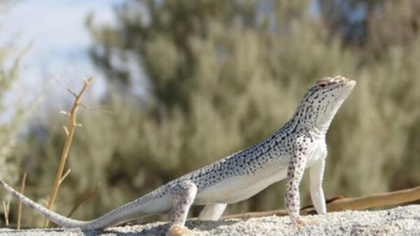
Dr. Mayhew knew there were several plants and animals endemic to the Coachella Valley sand dunes, species found nowhere else on earth. He knew that they would soon follow the great auk, the Carolina parakeet, and the ivory-billed woodpecker, into the abyss of extinction. He and others petitioned for what was clearly the most charismatic of the Coachella Valley’s endemic species, the Coachella Valley fringe-toed lizard, to be protected under the federal and California ESAs. In 1980, the Federal Fish and Wildlife Service and the California Department of Fish and Game agreed, granting the lizard protection. Any further development would bring the lizard that much closer to extinction and so legally such development should be halted. But it wasn’t. The rate of development didn’t even slow down. Dr. Mayhew and others threatened to sue the federal and state Government for their inaction. Local governments were not at all sensitive to the plight of a lizard. The then-Mayor of Palm Springs, Frank Bogert, ironically had a brother, Charles Mitchell Bogert, who was one of the top herpetologists in the United States. Frank would often claim his brother told him fringe-toed lizards were found on dunes everywhere across the southwestern U.S., so why should the Coachella Valley have to sacrifice its economic future for such a widespread and common lizard. I have a feeling Frank was only relating half-truths about what his brother told him. Yes, there are fringe-toed lizards on other dune systems, but they are different species. There are at least five species of fringe-toed lizard found on sand dune systems in California, Arizona, and Sonora, Mexico (with another two species in the Chihuahuan Desert of north-central Mexico.) The Coachella Valley fringe-toed lizard only lives in the Coachella Valley. Mayor Bogert would colorfully say that if the damn lizards were so important, then let’s move them to another dune system, ignoring that those other dunes were already occupied with other fringe-toed lizard species. Arguing that this species doesn’t matter would be like saying there are several species of penguin in the Antarctic so why would it matter if we willfully caused the extinction of one or more penguin species? Or, since there are Andean condors in South America, let’s go ahead and force the extinction of California condors.
Finally, a team was put together that included federal wildlife agencies, local governments, the building industry association, and The Nature Conservancy to develop a plan to protect the remaining dunes and the entire gamut of species that lived there. The problem was that none of them had ever had to solve a conservation problem that included a habitat that was always on the move. Protecting a grassland or a forest was relatively straightforward; define the boundary along with a buffer and protect it. This was more like protecting a river. Even if you protect a critical reach of the river, one dam upstream could negatively impact everything that lives there. The team, self-named the “Lizard Club” did their best and crafted the first-ever Habitat Conservation Plan (1986), with the assumption that the remaining sand corridors would be off limits to development. Who would want to live in the path of flooding and blowing sand? Importantly, the conservation plan recognized that this region’s economy was critical to preserve as well, and so it allowed ongoing development of those areas where that critical lifeline to moving sand had already been severed, where the “dam” was already in place. Over the following years, in areas where the ecosystem processes that allowed those pulses of sand to continue to flow had been severed, the fringe-toed lizards and all of the plants and insects found nowhere else but the Coachella Valley sand dunes disappeared. Dr. Mayhew’s prophetic vision of the loss of these unique species, unless the dunes were protected, was shown to be true.
That is when I got involved, working for the Nature Conservancy to ensure the Plan was implemented. There were many tasks, from getting the dune buggies to go elsewhere (BLM Rangers did a fabulous job helping to solve that problem), to address a handful of non-native highly invasive weeds, and to ensure those sand corridors stayed unobstructed. It turned out many people were very willing to “roll the dice” and build their dream home in a flood zone, hoping the next hurricane doesn’t happen while they were home. It was clear that the hardest problem was going to be managing to keep that “river of sand” open. That challenge ultimately led to expanding the original fringe-toed lizard Habitat Conservation Plan into a Multiple Species (27 species and their habitats) Habitat Conservation Plan. That process began in 1996 and finished in 2008. The new plan put added emphasis on protecting sand corridors, but implementing that objective continues to be challenging. Road and flood engineers' first response is to block flooding and sand movement, not to develop creative (but doable and cost effective) and innovative means of allowing that natural ecosystem level process to continue. The good news is some creative solutions appear to be on the horizon in some parts of the valley. The needed solution will always be how to work with nature, not how to thwart what nature has been doing for millennia. Hilary just showed us again how futile thwarting nature will always be.

