Geology
“I am here tracing the History of the Earth itself, from its own Monuments” — Jean-Andre De Luc
In December of 1831, when Charles Darwin set out from Plymouth England on the HMS Beagle, he was a geologist. Geology was the only field of science in which Darwin had anything resembling formal training. He attended geology lectures while at the University of Edinburgh in Scotland and later while studying to be an Anglican parson at Cambridge University in England. But his best instruction came just a month or two prior to his departure on the Beagle when he spent a week “geologizing” in Wales under the supervision of Adam Sedgwick, a Cambridge professor of geology.
Sedgwick was one of the leading geologists of the day and was responsible for identifying and naming the geologic periods of the Cambrian and Devonian. While sailing on the Beagle, Darwin read and re-read Charles Lyell’s treatise titled the “Principles of Geology,” the leading geology textbook of the day. As the Beagle made landfall on various oceanic islands and along the mainland of South America, Darwin was focused on describing and understanding the geology that he saw.
Years later, after returning to England, Darwin’s first publications were all focused on the geology he observed; some still stand today as a leading authority on, for instance, oceanic island formation, erosion, and coral reef development. However, Darwin’s geologic observations lead directly to his theory of natural selection. He found fossils in Argentina of giant ground sloths and armadillos and found marine fossils high in the Chilean Andes. The landscape and animals that lived there were not static; they had changed over time, from Pleistocene giants to today’s more diminutive tree sloths and dog-sized armadillos. That observation, and the geographic distribution of islands informed his theory. The Galapagos Islands are a relatively tight cluster of islands isolated from the mainland of South America by about 300 miles. The animals and plants Darwin encountered there were like those on the mainland, but different. The animals and plants were more similar within the island archipelago, but still different between the islands. His effort to explain these patterns led him to his theory of natural selection.
Understanding the where, when, what, and how of the patterns of life on earth begins with an understanding of geology and geography. Geography is the study of how features are distributed across a landscape. The rest is geology. Geology writ large, ranging from mountain building and erosion to the colliding and ripping apart of continents, to the minerals in rocks, all contribute to the stories of life. In forests, shrublands, and grasslands, the geology, the rocks, are shrouded in blankets of green leaves; glimpses of the underlying geology are often limited to fresh road cuts. One of the many joys of being a naturalist in deserts is that the geology is there for all to see, naked and revealing, open to all those willing to interpret the stories that are there to be read.
One of the first things to understand about geology is how old the rocks are. In the southern California deserts, the oldest rocks are 1.7 billion years old, the Pinto Gneiss from Joshua Tree National Park. The igneous rocks of the Santa Rosa and San Jacinto Mountains are by comparison relatively young. During the Paleozoic Era, some 250-550 million years ago, much of our desert region was covered by a shallow sea. Dolomite and limestone outcrops, scattered through the mid to lower elevations of these mountains are evidence of the marine sedimentary layers deposited during that period. As a result of subduction of the Farallon plate below the North American plate during the Mesozoic era, 65-250 million years ago, buoyant “plutons” of molten magma rose through the earth’s crust, erupting at the surface as an arc of volcanoes. The molten rock chambers below the volcanoes, the rising amalgamation of plutons, are referred to as batholiths. The still active volcanoes of the Cascade Range of Central Oregon, Washington and into British Columbia are the northern extension of a chain of volcanoes that once extended south into Baja California.
When the Farallon plate was fully subducted, the Pacific plate that had been pushing the Farallon plate eastward then slammed into the North American plate. But rather than subducting, the Pacific Plate slid northward creating what we now call the San Andreas transverse fault. Without subduction no more plutons rose from the earth’s magma. The batholiths were no longer being fed from below and so slowly cooled, forming hard crystalline igneous rock that is broadly referred to as granite combined with metamorphic gneisses and schists. From 20-65 million years ago, during the early to middle Cenozoic Era, volcanism south of what is now Mount Shasta and Lassen National Park ended. Volcanic cones built from extruded molten rock, primarily relatively soft and easily eroded basalt, began to erode so that today little or no evidence of their existence remains. The granitic and metamorphic batholiths below those volcanos began to rise about 20-30 million years ago forming the mountain chains we see today. As they grew in height, they increasingly created a rain shadow, causing plants and animals to adapt to that increasing aridity, or go extinct. By the late Miocene to early Pliocene Epochs, 2-10 million years ago, our deserts began to form.
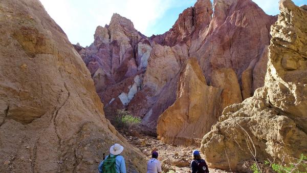
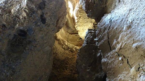
One of the geologically fascinating areas of the southern California deserts is the Mecca Hills, north and east of the Salton Trough. These hills are comprised of non-marine sedimentary rocks, sandstones, conglomerates, mudstones, and siltstones. The various layers have been tortured by the push and pull of the San Andreas Fault to the west, and the Eagle Canyon, Painted Canyon, Hidden Springs, and Grotto Faults that slice through this landscape. As the hardened batholiths were rising forming the mountains, those “sky islands” we know today, the surrounding landscape subsided forming the Salton Trough. That increasing difference in elevations increased water velocities in creeks and rivers, increasing erosion, increasing the deposition of gravels, sands, mud, and silt into the Salton Trough, filling the lower elevations 1.3 km deep with Pliocene-Pleistocene sediments. More recently, due to the San Andreas Fault, the region we now call the Mecca Hills uplifted, exposing the various layers of sediments that had from compaction now turned to rock. Geologists have traced the origins of those original sediments to have come from the Little San Bernardino and Cottonwood Mountains to the north and the Orocopia Mountain region to the east.
The surrounding rising mountains eroded forming debris flows and paleo river cuts to create what we now can see in the Mecca Hills. Debris flows resulting in chaotic jumbles of sand and cobbles, the riverine deposits yield more sorted layers with cobbles and small rocks indicating times of stronger river flows, and sands and silts representing low velocity flow. The chaotic layers from debris flows are about 330 meters thick and are referred to as the Mecca Conglomerate. The sorted riverine deposits overlay the Mecca Conglomerate, are about 340 m thick and are referred to as the Palm Springs Formation. The Palm Springs Formation provides habitat for an endemic perennial shrub, the Mecca aster, Xylorhiza cognata. Mecca asters are closely related to Mojave asters, X. tortifolia, which are found in the Little San Bernardino Mountains. One can imagine as debris was being eroded out of those mountains that seeds were also deposited. With millions of years of isolation in the Mecca Hills eventually a new species evolved.
Another endemic species resides nearby, the Orocopia sage, Salvia greatae. Orocopia sages appear to be “happiest” when growing on metamorphic Orocopia schist, although they also occur on the alluvial fans emanating from the Orocopia and Chocolate Mountains. A recent study headed by UC Riverside’s Melanie Davis indicated that those alluvial fan sages could represent “waifs,” seeds washed out of the Orocopia or Chocolate Mountains. The more stable populations appear to be up on the mountain slopes. Melanie’s team also found that there may be an upslope shift in those populations over recent decades, a shift that may indicate a response to hotter-drier downslope conditions due to climate change. Orocopia sages do not share similarities in leaf or flower characteristics with other desert or nearby mountain sages, indicating a long period of isolation. The Orocopia Mountain schist may be as old as 60-95 million years, 2-3 times or more older than the surrounding mountains. With that amount of time and isolation species have time to adapt and evolve. With an understanding of geology, better interpretations of life emerge.
Nullius in verba
Go outside, tip your hat to a chuckwalla (and a cactus), think like a mountain, and be safe.


