Natural History Notes from Saturday, June 27
Last week I posed a question regarding the different elevations where desert horned lizards occur in Joshua Tree National Park (abundant around 1400 m, and one sighting above 1500 m) compared to the highest record I am aware of in the Santa Rosa and San Jacinto National Monument of a mere 950 m.
The question is why? What I didn’t add is that difference is not limited to desert horned lizards. Chuckwallas in the Park can also be found up to 1400 m whereas in the Monument only to about 1050 m; Zebra-tailed lizards in the Park have recently been sighted around 1350 m, and in the Monument, I know of a very small population at 1100 m. These differences are not trivial, so again, why?
Once more you came through with excellent hypotheses. Peter Schwartz speculated that natural selection may have been at work, resulting in genetic differences that allow the Park lizards to take advantage of what may be better food resources at those higher elevations. Then Sue Shigenaga (class of 2018) observed that the San Bernardino Mountains are higher than the San Jacinto and Santa Rosa Mountains. Higher mountains create a stronger rain shadow, and so the Park may be more arid than the Monument. For lizards of the same species occurring in both the Park and the Monument, those in the Park would then need to exploit higher elevations to find similar levels of rainfall and similar food resources their cousins in the Monument would enjoy. I love these ideas, but then how to test them? It would be easy enough if there were dozens of weather stations across both areas, but there aren’t. However, vegetation patterns may be a surrogate for weather stations. Many of the same plant species do occur in both areas: pinyon pines, California junipers, Muller’s oak and even creosote bush are some candidates that occur at the right elevations. Something to investigate this fall.
With the official start of summer this past week, we are also entering wildfire season. Wildfires have already started, with one a week or two ago in Arizona, just north of Phoenix, reaching 100 square miles almost overnight. There have also been a couple small fires closer to home, south of Palm Springs and Cathedral City, fueled by the invasive and non-native cape needle grass. Every year the fire season gets worse, a trajectory consistent with climate change predictions of higher temperatures and higher aridity.
While climate change is a factor, so is the way we manage our shrublands and forests, and how we think about fire. We all grew up with Smokey the Bear and so we “know” that fires are destructive to wildlife and their habitats. Not too long ago, many of our ancestors lived in wooden houses in densely populated villages and cities. A small fire could then easily burndown the whole city (remember the 1871 Chicago fire, allegedly started by Kate O’Leary’s cow kicking over a lantern – nearly the whole city was lost). Fires are destructive, feared and to be stopped at all costs. Or maybe not.
Except for deserts, (which before nonnative invasive grasses didn’t have enough continuous fuel to carry fires), fire is an integral part of the ecology of almost every other ecosystem on earth, critical for nutrient cycling, stimulating the growth of annual plants, and revitalizing plants that have otherwise become senescent and less productive. Plants and animals in these fire habitats have adaptations that allow them to survive and thrive under an appropriate fire regime. Fire outside of deserts is an essential ecosystem process. When fire is kept out of these forests, shrublands, and grasslands, they then accumulate fuels and when they inevitably do burn they become a serious threat to us. The indigenous peoples of the Americas knew this. They used fire as a tool to their benefit, increasing habitat productivity, increasing wildlife, increasing the abundance of food plants, reducing the incidence of big destructive fires, and in doing so made it easier to walk across the landscape where they live (try walking through a stand of chaparral that hasn’t been burned for a century). Unfortunately, as people from those eastern and midwestern cities made of wood moved onto these lands, they brought their fear of wildfire with them. The burning by indigenous people was largely halted.
There is one place not too far from here where you can still see indigenous land management in practice. I haven’t done this for years, but we used to go camping in Baja California every year, and to avoid the crowds at the international border we would often cross at Tecate (about half way between Mexicali and Tijuana and famous for pottery, glazed tiles, health spas, the beer they brew there, and shorter waits at the border). From there on to Ensenada, down the coast and across to Cataviña and finally to Bahia de Los Angeles on the Gulf of California. That stretch between Tecate and Ensenada goes through chaparral and coastal sage scrub before reaching the wine country a bit north of Ensenada. We would head down there in the summer, when it was hot and dry, and would see dozens and dozens of small fires creeping across the hillsides. No fire companies fighting fires, just occasional ranchers, steeped in their indigenous culture, casually keeping an eye on the fires as they slowly crept among the shrubs.
A (now retired) professor at UCR, Dr. Richard Minnich, analyzed wildfire sizes in eastern San Diego county on the US side of the border and compared those south of the border. You can get on Google earth and do the same analysis. What he found was that wildfires were typically hundreds of thousands of acres on the north side, and generally 20 acres or less to the south of the border. There are some people talking with the few indigenous people who still understand fire as a tool, and perhaps over time they will radically change the way we currently manage our forests and shrublands. Stopping all fires was wrong (and ultimately impossible) but now as fuels have accumulated and climate change has intensified the size and damage wildfires cause, there needs to be a new approach, which perhaps means embracing an old approach.
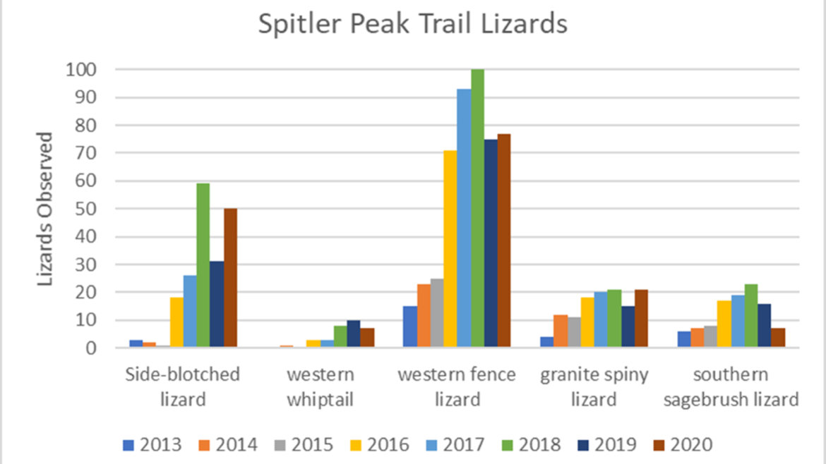
The idea that fires might be good for wildlife and their habitat goes against everything Smokey the Bear told us. I drank that same Kool-Aid. At least until a few years ago when I had an opportunity to test that idea. Back in 2013 I was realizing the need to collect baseline data to be able document whether or not climate change was impacting our desert wildlife. I expected species would be shifting upslope if climate change was happening and changing habitats. In addition to low elevation sites where I might detect upslope shifts at the “bottom” of their ranges, I wanted some high elevation sites to see if species might also be move up at the “top” of their range. Near Lake Hemet at the north end of Garner Valley in the San Jacinto Mountains, the Spitler Peak trail looked like a good candidate. So, in early July of 2013 I conducted my first lizard survey there; one week later the “Mountain Fire” was ignited by a faulty electrical hook-up and the entire trail (and beyond) was burned to a crisp. Always looking to make lemonade from lemons, I assumed that, by removing all the shade trees and shrubs, I might get an accelerated picture of what climate change might do to our region.
Yesterday (6/26/2020) we conducted our 8th annual survey of lizards on the Spitler Peak trail. Sue Shigenaga, Tracy Bartlett, Larry Heronema, and Colin Barrows (all class of 2018), joined to make sure we saw every lizard that was available to be seen. The habitat is still restoring itself from what I saw in 2013. The only species that are gone, and showing no signs of returning are conifer trees, otherwise oaks and chaparral shrubs are all doing very well. However, my idea that the lizards would be decimated by the fire and the ensuing heat and aridity was completely wrong. In fact, the lizard populations have grown far faster there than any nearby sites that were missed by the fire.
Why? I think that there were a couple reasons. One was that by opening up the dense forest and shrubs, new thermal niches became exposed and were quickly exploited by the lizards. Also, in the years following the fire the annual plant diversity was more than twice as rich and abundant than on those nearby unburned sites. Plants botanists call fire-followers, because their appearance is dependent on recent fires, were abundant, and so were insects taking advantage of those fire followers. All were food for the lizards.
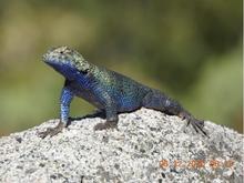
I am attaching a graph to show how each lizard species responded – remember the 2013 survey was pre-fire. I was wrong, really wrong. But that is what science is all about. We do not learn by confirming what we believe to be true, we learn when those preconceptions are challenged. I’m also attaching an amazing image (eye candy) of a granite spiny lizard taken by Larry last week on a nearby trail.

